|
Doors |
|
|
Cabell
County |
|
Hensley Cemetery
HENSLEY
CEMETERY
Cabell County, West Virginia
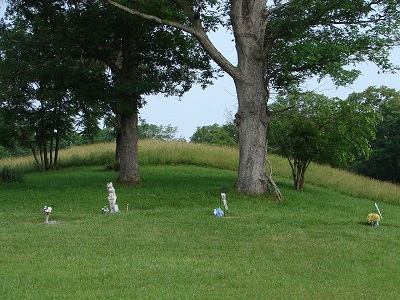
Latitude: N 38ş 20. 365 From Huntington Follow Rt. 10 to Upper heath Creek Road. Turn Right onto this road and go .04 of a mile. Turn up a gravel road and go to last house. Stop at this house and asked permission to go up to the cemetery. The road to the cemetery is on the upper side of the barn. Take this road up the hill to the field and the cemetery will be in the upper end of the field. The cemetery is not fenced but is maintained. The picture above is a picture of the Tooley Cemetery. The Hensley Cemetery is located above the Tooley Cemetery and is between the big trees. There are no marked graves. The graves at one time were marked with field stones but were later removed so the grass could be keep cut. There were no burials after 1940's. There are 5 or more sunken areas where the graves were located. The names are unknown. Read June 10, 2011. Information by Dennis Hensley
|