BY ROYAL DECREE
( The Savage Grant )
------------------------------------------------------------------------------------------------------
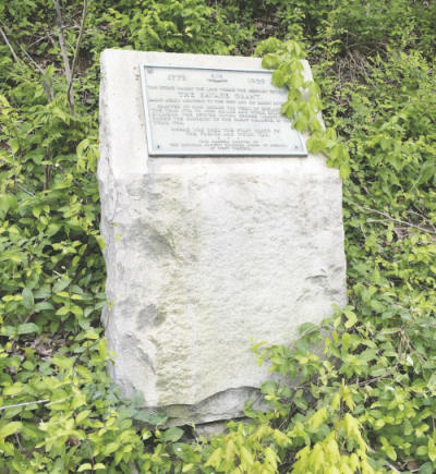
In 1930, the National Society of Colonial Dames in American
dedicated this stone marker on U.S. 60 that commemorates
the Savage Grant.
------------------------------------------------------------------------------------------------------
HUNTINGTON -- If you drive U.S. 60 from Huntington
heading for the Huntington Mall, you might see a small stone
monument perched on the east side of the highway. It's located just a bit
beyond the intersection
with Barboursville's Main Street, across the roadway from Adams Trucking.
Thousands of
motorists travel the road every day and never notice the marker. Of those who
do spy it,
few realize it recognizes an important chapter in the region's history.
Dedicated April 10, 1930, by the West Virginia chapter of
the National Society of
Colonial Dames in America, the granite marker commemorates the Savage Grant.
On Dec. 15, 1772, John Murray, Virginia's royal governor,
acting as agent for King George III,
granted more than 28,000 acres along the Ohio River and the lower Guyandotte
and Big Sandy
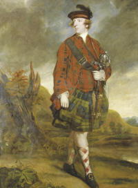
rivers to John Savage and 59 other men who had served under George Washington
at the
1754 Battle of Great Meadows, Pennsylvania, in the French and Indian War.
Murray, the fourth Earl of Dunmore, generally known as Lord
Dunmore, was a Scottish peer and
the last colonial governor in the American colonies. As Virginia's
governor, he directed a
military campaign against the Native Americans in the Ohio Valley, known
as
Lord Dunmore's War. A highlight of that conflict was the 1774
Battle of Point Pleasant, which saw Col. Andrew Lewis
decisively defeat a band of Shawnee warriors led
by the legendary Chief Cornstalk.
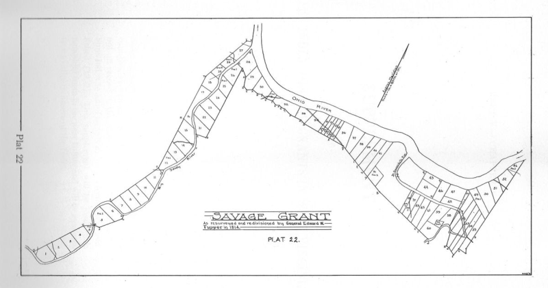
The land grant Dunmore issued ran along the Big Sandy River
from a point near
present-day Fort Gay, West Virginia, and Louisa, Kentucky, extending north
to where the river joins the Ohio, and on the Virginia (now West Virginia)
side of the Ohio for about 20 miles along the present sites of Kenova,
Ceredo, Huntington and Guyandotte. It also included an area of the
Guyandotte River extending from its mouth to the
present site of Barboursville.
Savage never settled on his land, nor did most of the other
soldiers. Many of them sold
their land. Others lost their grants because they failed to make the
required
improvements to their property, and a few forfeited
their grants for nonpayment of taxes.
In 1775, some of the grantees met on the land grant and drew
up a partial division. A year later,
after differences arose among some of the grantees or their heirs, a suit
was brought in the
Superior Court at Staunton, Virginia, asking that the earlier division be
voided.
The court appointed five men to act as a commission
to divide the grant into equal parts.
The commission hired General Edward W. Tupper to conduct a
survey.
It wasn't until 1814 that Tupper completed his work. He divided the
grant into 61 equal parcels of approximately 460 acres each,
beginning with Lot 1 at the western end of the grant and
terminating with Lot 61 on the eastern end. In 1819,
the court upheld Tupper's division.
The Savage Grant would play a key role in the establishment
of the village of Guyandotte.
William Buffington purchased 20 acres at the mouth of the Guyandotte River
from
Jonathan Savage's grant and willed the parcel to his sons, Thomas and Jonathan
Buffington. The sons came about 1796 and settled on the tract. Thomas
built his house on the east side of the Guyandotte,
while Jonathan built on the west side.
Other settlers followed the Buffingtons, and a little
settlement grew up.
When Cabell County was carved out of Kanawha County in 1809,
Guyandotte was designated as its first county seat, and in 1810,
Virginia's General Assembly chartered Buffington's
20 acres as the town of Guyandotte.
Guyandotte thrived in its early years. By 1831 daily service
had been extended
westward from Richmond, Virginia, via the James River and Kanawha
Turnpike to Guyandotte, where connections could be made
with the busy steamboats that traveled the Ohio.
But when railroad tycoon Collis P. Huntington arrived on the
scene and, in 1871,
established his new town of Huntington, the new community boomed and
soon outstripped Guyandotte. In 1910, Guyandotte celebrated its
centennial, but the following year it bowed to the inevitable
and voted to be annexed into Huntington.
Much of the property that Huntington purchased for his new
town had originally
been part of the Savage Grant. Similarly, Ceredo and Kenova
were built on land that had been part of the grant.
( George was the last king of England to rule over the American Colonies. )
The stone marker on U.S. 60 commemorating the grant reads as follows:
"This stone marks the line where the highway enters THE
SAVAGE GRANT - 28,637 acres,
reaching to the Ohio and Big Sandy Rivers. Granted by King George the Third,
of England,
in the year 1772, to John Savage and Other Colonial Soldiers, who served
under George
Washington, during the Campaign of the Great Meadows, in the Year 1754. Where
was
shed the first blood of the French and Indian War. This Marker erected by
the
National Society Colonial Dames of America, of West Virginia."
The marker could face an uncertain future.
Barboursville has asked the West Virginia Division of
Highways to widen U.S. 60
at the entrance to the Tanyard Station retail complex, now being developed
at the intersection of U.S. 60 and Meritts Creek Road. Doing so will
be needed, said Mayor Chris Tatum, to improve
access to and from the new development.
Any widening of U.S. 60 seems certain to force a move of the
marker
elsewhere as it's situated right at the side of the existing roadway.
Tatum has said that "ultimately what we would like to see
and what we're asking for
from the state is to have Route 60 widened all the way to Mall Road.
We feel like it can be done, and that's kind of the end goal for us."
Another small marker commemorating the Savage Grant is
located on the north side of
Washington Boulevard, just beyond Hal Greer Boulevard. It was placed by the
Buford Chapter of the Daughters of the American Revolution in 1916.
Note: This Article and picture appeared in the Herald-Dispatch Newspaper on May 6, 2017.
-----------------------------------------------------------
[ Back ]