|
Doors [ Back ] -------------------- -------------------- -------------------- Last Hanging in Huntington 1892 -------------------- Barboursville -------------------- -------------------- Early Pioneer of Cabell County -------------------- -------------------- -------------------- -------------------- -------------------- -------------------- -------------------- |
|
|
Doors to the Past |
|
Cabell CountyCabell County History Located in Southwestern West Virginia along the Ohio River, Cabell County was created by an act of the Virginia General Assembly on January 2, 1809 from part of Kanawha County. It was named in honor of William H. Cabell (1772-1853), who served as Governor of Virginia from 1805 to 1808. He was born on December 16, 1772 in Cumberland County Virginia, graduated from William and Mary College in 1793 and began practicing law in Richmond the following year. He was chosen as a representative to the Virginia General Assembly from Amherst County in 1796 and was re-selected six times until his election as Governor. After serving for three years as Governor, he served as a Judge of the General Court until 1811 and then a Judge of the Virginia Court of Appeals until his retirement in 1841. He served as the President of the Court from 1822 until his retirement in 1841. He died on January 12, 1853 in Richmond.
The first native settlers along the Ohio River in the area of present-day Cabell County were the Mound Builders, also known as the Adena people. Remnants of the Mound Builder's civilization have been found throughout the Ohio River Valley, with a high concentration of artifacts located at Moundsville, West Virginia, just north of the county (in Marshall County). The Grave Creek Indian Mound, located in the center of Moundsville, is one of West Virginia's most famous historic landmarks. More than 2,000 years old, it stands 69 feet high and 295 feet in diameter. According to missionary reports, several thousand Hurons occupied present-day West Virginia during the late 1500s and early 1600s. They were driven out of the state during the 1600s by members of the powerful Iroquois Confederacy (consisting of the Mohawk, Onondaga, Cayuga, Oneida and Seneca tribes, and joined later by the Tuscaroras tribe). The Iroquois Confederacy was headquartered in New York and was not interested in occupying present-day West Virginia. Instead, they used it as a hunting ground during the spring and summer months. During the early 1700s, the Ohio River valley, including present-day Cabell County, was primarily used as hunting grounds by the Ohio-based Shawnee, the Mingo, who lived in both the Tygart Valley and along the Ohio River north of Cabell County, and the Seneca, one of the largest and most powerful members of the Iroquois Confederacy. The Shawnee settled in villages along the Ohio River, primarily in the area between present-day Wood and Cabell counties. Following the construction of Fort Pitt in 1758 by the British, the Shawnee moved further in-land and built a series of villages along the Scioto River in southern Ohio. These villages were collectively known as Chillicothe and served as their base camp for hunting and fishing in present-day West Virginia. The Mingo were not actually an Indian tribe, but a multi-cultural group of Indians that established several communities within present-day West Virginia. They lacked a central government and, like all other Indians within the region at that time, were subject to the control of the Iroquois Confederacy. The Mingo originally lived closer to the Atlantic Coast, but European settlement pushed them into western Virginia and eastern Ohio. The Seneca, headquartered in western New York, was the closest member of the Iroquois Confederacy to West Virginia, and took great interest in the state. In 1744, the Seneca boasted to Virginia officials that they had conquered the several nations living on the back of the great mountains of Virginia. Among the conquered nations were the last of the Canawese or Conoy people who became incorporated into some of the Iroquois communities in New York. The Conoy continue to be remembered today through the naming of two of West Virginia's largest rivers after them, the Little Kanawha and the Great Kanawha. The Seneca, and other members of the Iroquois Confederacy, claimed all of present-day West Virginia as their own, using it primarily as a hunting ground. Also, war parties from the Seneca and other members of the Iroquois Confederacy often traveled through the state to protect its claim to southern West Virginia from the Cherokee. The Cherokee were headquartered in western North Carolina and eastern Tennessee and rivaled the Iroquois nation in both size and influence. The Cherokee claimed present-day southern West Virginia as their own, setting the stage for conflict with the Iroquois Confederacy. In 1744, Virginia officials purchased the Iroquois title of ownership to West Virginia in the Treaty of Lancaster. The treaty reduced the Iroquois Confederacy's presence in the Ohio River Valley. During the mid-1700s, the English had made it clear to the various Indian tribes that they intended to settle the frontier. The French, on the other hand, were more interested in trade. This influenced the Delaware, Mingo, and Shawnee to side with the French during the French and Indian War (1755-1763). Although the Iroquois Confederacy officially remained neutral, many in the Iroquois Confederacy also allied with the French. Unfortunately for them, the French lost the war and ceded the all of its North American possessions to the British. The Mingo retreated to their homes along the banks of the Ohio River, and the Shawnee retreated to their homes at Chillicothe. Although the war was officially over, many Indians continued to see the British as a threat to their sovereignty and continued to fight them. In the summer of 1763, Pontiac, an Ottawa chief, led raids on key British forts. Shawnee chief Keigh-tugh-qua, or Cornstalk, led similar attacks on western Virginia settlements in present-day Greenbrier County. By the end of July, Indians had captured all British forts west of the Alleghenies except Detroit, Fort Pitt, and Fort Niagara. Then, on August 6, 1763, British forces under the command of Colonel Henry Bouquet retaliated and destroyed Delaware and Shawnee forces at Bushy Run in western Pennsylvania, ending the hostilities. Fearing more tension between Native Americans and settlers, England's King George III issued the Proclamation of 1763, prohibiting settlement west of the Allegheny Mountains. However, many land speculators, including George Washington, violated the proclamation by claiming vast acreage in western Virginia. The next five years were relatively peaceful on the frontier. In 1768, the Iroquois Confederacy (often called the Six Nations) and the Cherokee signed the Treaty of Hard Labour and the Treaty of Fort Stanwix, relinquishing their claims on the territory between the Ohio River and the Alleghenies to the British. With the frontier now open, settlers, once again, began to enter into present-day West Virginia. In 1772, a series of incidents between settlers and Indians in West Virginia ended what had been nearly eight
years of peace. During the spring of that year, several
Robert Cavelier de La Salle was probably the first European to set foot in present-day Cabell County. He sailed down the Ohio River in 1669. The earliest English explorers to enter Cabell County were probably Thomas Batts and Robert Fallam. They explored the area in September 1671. When Batts and Fallam explored the county they found trees marked in coal with the letters MANI and M.A., signifying that other Englishmen had been there before them. In 1749, Louis Bienville de Celeron explored the Ohio River and may have landed in Cabell County. He claimed all of the lands drained by the Ohio River for King Louis XV of France. He met several English fur traders on his journey and ordered them off French soil and wrote strong letters of reprimand to the colonial governors protesting the English's presence on land claimed for France. Mary Ingles was probably the first English women to pass through what would later be Cabell County. She, and Betty Draper, were captured by Indians at Drapper Meadows, Virginia (now Blacksburg) on July 8, 1755 and taken by the Indians through the county as they made their way to the Shawnee Village at Chillicothe, Ohio. Mary Ingles escaped four months later and may have passed through the county on her return to Virginia. In 1772, a grant of 28,628 acres, including much of the current county, was made to John Savage and 60 other persons for military service during the French and Indian Wars (1754-1763). William Buffington of Hampshire County purchased lot 42 of the Savage Grant from John Savage and willed it to his two sons, Thomas and William Buffington. Thomas Buffington and his brother, Jonathan, came to present-day Cabell County in 1796 and found Thomas Hannon, who had settled along the Little Guyan River. Hannon is regarded as the first, permanent English settler in Cabell County. Soon after building his cabin, Jonathan was out hunting and returned to find it burnt to the ground by Indians and all of his family, except for one daughter, murdered and scalped. The daughter was captured by the Indians. He chased the Indians, but was captured and forced to run the gauntlet. He survived the gauntlet and was allowed to return home, but he never found his daughter. However, in 1901, at the Pan-American Exposition in Buffalo, New York, an Indian Chief named Jonathan Buffington was in attendance, suggesting that the captured girl may have named her Indian children in honor of her father.
Throughout the 1800s, Cabell County's location along the Ohio River made it a natural resting place for settlers headed to the frontier lands in the west. Prior to the Civil War (1861-1865), many settlers followed primitive Indian trails to the west. Several of these trails passed through the county. On the advice of George Washington, Virginia commissioned the James River Company to upgrade these trails into roads. One of the company's largest and most important road project was the James River and Kanawha Turnpike. The turnpike traversed the frontier from Lexington, Kentucky to Charleston, Virginia. In 1814, the road was extended to Barboursville in present-day Cabell County. In 1837, Marshall Academy, predecessor of Marshall University, was formed. One of the Academy's founders, local lawyer John Laidley, recommended that the school be named in honor of his friend, John Marshall, the late Chief Justice of the U.S. Supreme Court. Marshall Academy was a "subscription school" serving the wealthier families in the Cabell County vicinity. It was incorporated in 1838 by the Virginia State Legislature. In 1867, the new state of West Virginia created the State Normal School of Marshall College to train teachers. Marshall College continued to increased in size and, in 1961, achieved the status of University. Although most of the state's residents sided with the Union during the Civil War, the residents of present-day Cabell County were divided. Trouble began when, Eli Thayer, an abolitionist congressman from Massachusetts, spoke to some citizens in the county in 1857. Thayer supported the creation of colonies of northern workers in southern states. He hoped this would change the social makeup of the state, and turn the tide against slavery. The newspapers in Richmond chided the residents of Cabell County for allowing a Yankee abolitionist to meddle in the affairs of the state of Virginia. After the Thayer controversy, many Cabell County citizens organized to pledge their allegiance to the state of Virginia. As the country moved closer to war, tensions in the county began to rise. After the election of President Lincoln in 1860, some of the county's citizens organized a militia loyal to the South known as the Border Rangers. William McComas, Cabell County's representative to the Virginia secession convention of 1861, voted for Virginia to remain in the Union. Although McComas voted as a unionist, the area's congressman, Albert Gallatin Jenkins, who owned a farm in the county, was a staunch secessionist. He was the leader of the Border Rangers. Jenkins later became a General in the Confederate Army, and was wounded in battle at Gettysburg. While Virginia, as a whole, voted to secede from the Union, Cabell County's citizens voted to remain in the Union. However, the town of Guyandotte, located within the county, voted to secede. The first engagement during the Civil War in Cabell County was the Battle at Barboursville on Fortification Hill in 1861. The 2nd Kentucky regiment entered the town and, after some minor fighting, dispersed the local militia. Later that year, a Confederate force attacked a Union recruitment station at Guyandotte. The Confederacy won the day with the assistance of several local residents who distracted the Union recruiters while the Confederates launched their surprise attack. The Union Army later recaptured the town and set it on fire to punish its citizens for aiding the Confederacy. Two-thirds of the town was burnt to the ground. After the town's destruction, the Unionist Newspaper the Wheeling Intelligencer declared Guyandotte "the worst secession nest in that whole country. It ought to have been burned two or three years ago." The county's economy become stagnant during the Civil War, and the burning of Guyandotte, one of the county's major population centers, was a major blow to the local economy. However, the county's proximity to the Ohio River and the building of the railroad by Collis Huntington, played a major role in the region's economic recovery and its future success. Legend has it that when Collis Huntington visited the county to decide where to place his railroad that he was initially interested in using Guyandotte as the railroad's end-point. However, when he arrived there, he tied his horse to the hitching post in front of the local hotel and it somehow reversed its position and ended up on the sidewalk. The town's mayor, seeing the horse, entered the hotel and demanded to know who the owner of the horse was. After identifying himself as the horse's owner, Mr. Huntington was fined by the mayor. Not liking his reception, Mr. Huntington announced the next day that he would not locate the railroad in Guyandotte but would, instead, build a new town (later called Huntington) just west of Guyandotte and make it the western terminus for his railroad. Ironically, Guyandotte was later merged into Huntington.
In the early 1900s, industrial development occurred throughout Cabell County and in the fledgling city of Huntington. The glass industry, a flour mill, furniture manufacturers, and, in 1921, the International Nickel Company opened a plant near Guyandotte. The new industry brought economic success and population growth to the county. In 1923, Huntington became home to the state's first radio station and, in 1949, the state's first television station. The construction of Interstate 64 through the county during the 1960s strengthened the local economy by providing ready access to Charleston and the rest of the state.
The first meeting of the Cabell County court took place in 1809 the home of William Merritt who was living in or near the present town of Barboursville. The county seat was then located at Guyandotte and remained there until 1814, when it was moved to Barboursville. In 1863, the county seat was returned to Guyandotte for two years because Barboursville was controlled by the Confederate Army. Following the Civil War, Barboursville was, once again, named the county seat (in 1865). It continued to be the county seat until 1887 when the county voters moved it to Huntington. Huntington was settled in the early 1800s. James Holderby was one of the first settlers in present-day Huntington. He purchased a farm on lands within the city in 1821. At about that same time, Richard and Benjamin Brown established a river landing for boats nearby, then known as Brownsville. Huntington, currently the second most populated city in the state, was incorporated by an act of the West Virginia State legislature on February 27, 1871 and named in honor of Collis P. Huntington, President of the Chesapeake and Ohio Railroad.
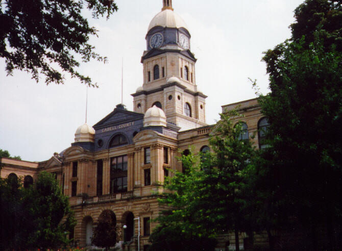
One of the first orders of business following Huntington's selection as the new county seat of government was where to build the new county courthouse. A site between Fourth and Fifth Avenues and Seventh and Eighth Streets was selected and purchased for $24,757. On May 8, 1895, the County Court, then composed of B. H. Thackston, President, and C.H. Morris and C.C. Dickey entered an order that the court would receive plans and specifications for a courthouse that would:
The building was subsequently built of Berea sandstone with a copper roof. On July 21, 1896, the contract for the construction was let to Charles A. Moses. The first corner stone was laid on November 11, 1899. There was a large parade and a grand ceremony to mark the event. The Courthouse was completed on December 4, 1901. In 1923, construction was undertaken on the west wing. The contract was awarded to King Lumber Company at a cost of $133,900, paid for a three year levy. Then, on August 22, 1938, Frampton & Bowers, architects, were hired to prepare the plans for the new jail and for an east wing to the Courthouse. On December 28, 1938, the contract was awarded to Engstrom and Wynn of Wheeling, West Virginia, for this construction and remodeling in parts of the old building. It was completed March 16, 1940. The cost of the east wing was $208,000 and the cost of the jail was $246,000 for a total cost of $454,000.
Casto, James E. 1985. Huntington: An Illustrated History. Northridge, CA: Windsor Publications, Inc. Cabell County, West Virginia Heritage 1809-1906. 1996. Marceline, MO: Walsworth Publishing Company. Geiger, Joe Jr. 1991. Civil War in Cabell County, WV 1861-65. Charleston, WV: Pictorial Histories Publishing. Rice, Otis K. 1985. West Virginia: A History. Lexington, KY: The University of Kentucky Press. Wallace, George Selden. 1935. Cabell County Annals and Families. Richmond, VA: Garrett & Massie Publishers Williams, John Alexander. 1993. West Virginia: A History for Beginners. Charleston, WV: Appalachian Editions.
Dr. Robert Jay Dilger, Director, Institute for Public Affairs and Professor, Department of Political Science, West Virginia University. Steve Kovalan, undergraduate history major, West Virginia University. August 1, 2000.
A special Thank's to the Cabell County
Commission
|